
Embracing IoT and AI for Forest Protection: Lessons Learned and the Path Forward for the Forest Fire Detection Early Warning System
Exploring the challenges, insights, and future roadmap of the technology-driven forest fire detection project in collaboration with WWF-Pakistan, KPK Forest Department and FTL
By Dr. Murtaza Taj and Ali Akbar Abbas
This story was originally published in Medium
In our previous post, we discussed the launch of a collaborative project between LUMS, WWF, and the Khyber Pakhtunkhwa (KPK) Forest Department aimed at developing an innovative, technology-driven, forest fire early warning system using AI, Computer Vision, IoT and remote sensing technologies. The project was divided into a series of sprints, with each sprint focused on specific objectives and milestones.
In Sprint 1 we conducted research to identify suitable technologies, machine learning (ML) models, and equipment for developing an effective forest fire early warning system. We focused on exploring options for cameras, local processing units, towers, power sources, ML models, weather stations, IoT sensors, and existing datasets with the aim of understanding whether the low-cost tech could be used to detect forest fires and build a scalable early warning forest fire system. Having identified suitable cameras and IoT equipment, and shortlisted promising ML models for fire prediction, we set up sprint 2 to deploy the technology in field, gather field data, fine-tune the AI models, and seamlessly integrate all components into a user-friendly dashboard for deploying the forest fire early warning system.
Our primary goal was to learn how to effectively integrate various technologies and data sources to develop a comprehensive Early Warning System (EWS) for forest fires. We aimed to understand and learn the feasibility and challenges of a forest fire detection system built using AI cameras and IoT sensors, and a forest fire prediction system utilising remote sensing and real-time weather stations to measure spread, as well as the ability to integrate these elements into a user-centric, multi-data source dashboard. We also sought to explore how we could integrate a community- based early warning system solution into the system and evaluate its potential to enhance the EWS. By testing a series of assumptions, we aimed to gather insights for improving the system, ensuring its scalability, and facilitating its adoption by relevant stakeholders.
Throughout this article, we will provide a detailed overview of the activities carried out during sprint 2, the challenges encountered, and the lessons learned. We will also delve into understanding the pressing needs of the KPK Forest Department, the role of IoT in fire detection and culprit identification (when fire is caused by human negligence), the importance of public-private partnerships and the role of our partner organization on this pilot, WWF Pakistan, as well as the future roadmap for using IoT in forest research and protection.
Key Attributes of the Multi-Modal Forest Fire Early Warning System
Most forest fire detection systems already deployed around the world typically use thermal cameras or multi-spectral cameras as they are highly effective in identifying heat signatures in a wide range of lighting and weather conditions. However, such systems are costly and unfeasible for forests with patch-reserves smaller than 200 hectares, spanning only 4–5kms. This issue is compounded by the lack of local infrastructure and supply chains to support the maintenance and upkeep of such systems. Here we explore a feasible solution for such reserve forests. The key attributes of the system that we explored in our pilot are as follows:
• Pan, tilt and zoom-capable (PTZ) cameras at multiple locations for forest fire early warning via visual analysis and AI models for automatic early fire detection
• LoRa-based low bandwidth communication networks for IoT sensors and IoT Weather stations
• Machine learning models and algorithms for remote sensing-based hotspot prediction, fire spread and direction, and mapped visualisation to help firefighting teams plan more effective and safe responses to forest fires (models tuned to three pilot locations)
• Integration of raw data and event data from sensors, cameras, and remote sensing into a common database for building an end-user dashboard and presenting it in a user-friendly way
• Integration of WhatsApp for Business, SMS, or another solution to enable community-based early warning alerts
During the research we conducted in our first sprint; we learnt that the standard PTZ cameras are suitable for continuous visual monitoring as they allow up to 32x optical zoom and are almost 10 times more cost-effective compared to thermal cameras. This cost saving allowed us to increase the number of watch towers to 3, and allowed us to integrate a wide-variety of low-cost, low power, and low-bandwidth IoT sensors in our solution. We also learned that these IoT sensors provide complementary information which can help in overcoming the limitation of optical sensing while keeping the solution cost effective. However, it increases the complexity of the system as there is an additional need to establish network connectivity with the sensors and integrate information from heterogenous sources. Furthermore, another learning from the first sprint was that only limited data sets are available for predicting the forest fires and their spread, and the datasets for Pakistan were required to be developed. Considering all this, it was crucial to test the proposed system in a controlled environment before the field deployment, allowing us to integrate components and collect the necessary datasets for AI models. This became our first task of the second sprint.
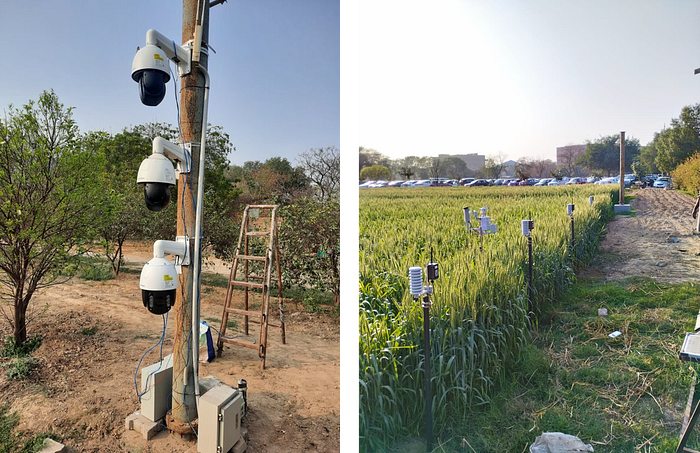
We have an excellent on-campus facility, the LUMS Digital Sustainable Agriculture Facility, which we use as a living lab to test various digital technologies in realistic environments. At the beginning of the second sprint, we deployed all available equipment, including PTZ cameras, Automatic Weather Stations, and IoT sensors, in the LUMS facility and fine-tuned the models for remote sensing-based solutions to the specific conditions of the LUMS facility, allowing us to test a comprehensive intervention for the location. This enabled us to build an MVP (Minimum Viable Product) to prove that the technology was working as expected and to understand the impact various weather conditions might have on the hardware outside of the controlled lab environment.
During this deployment, several aspects of the system were carefully analysed and improved. For example, the edge-based AI module was tweaked to reduce the transmission of data. As compared to motion triggered cameras, which capture and process images only when motion sensor is triggered, forest fire detection requires continuous acquisition and processing of images. These images are first processed at the watch tower using edge-based AI and then transmitted to the central server for further analysis. The edge-based AI was tweaked such that it only transmitted images when the fire/smoke detection threshold exceeded a certain value. Furthermore, fire/smoke incidents typically last several hours, thus we also increased the idle time of the system to over 30 minutes and have the ability to further adjust this based on seasonal needs. This reduced the power and resource consumption at the tower.
Another important aspect is the operating temperature of the system. Since the system is expected to work in hot temperatures during summer months, the heat generation of the system was carefully analysed to ensure that the temperature does not exceed 80 degrees centigrade even during high-compute intervals. This was achieved by including additional cooling fans. This analysis helped in saving significant time and resource which we would have incurred if the system was instead deployed at a remote forest site. It also resulted in a smooth deployment experience and helped in reducing the deployment time to just two days per site, including the required civil works (more on this in the next section).
What happened in practice
Our top priority of this sprint was to integrate and deploy all hardware components in a manner that would allow for easy disassembly and reinstallation at the pilot site. Three different teams worked independently on their respective deployments and field activities, including the installation of fire detection cameras, the deployment of IoT sensors and weather stations, and the collection of field data for remote sensing and AI models. Though with its own set of challenges, the opportunity allowed us to gain valuable learnings which will inform our future efforts in creating more effective and adaptable forest fire detection systems.
Fire Detection Cameras Installation
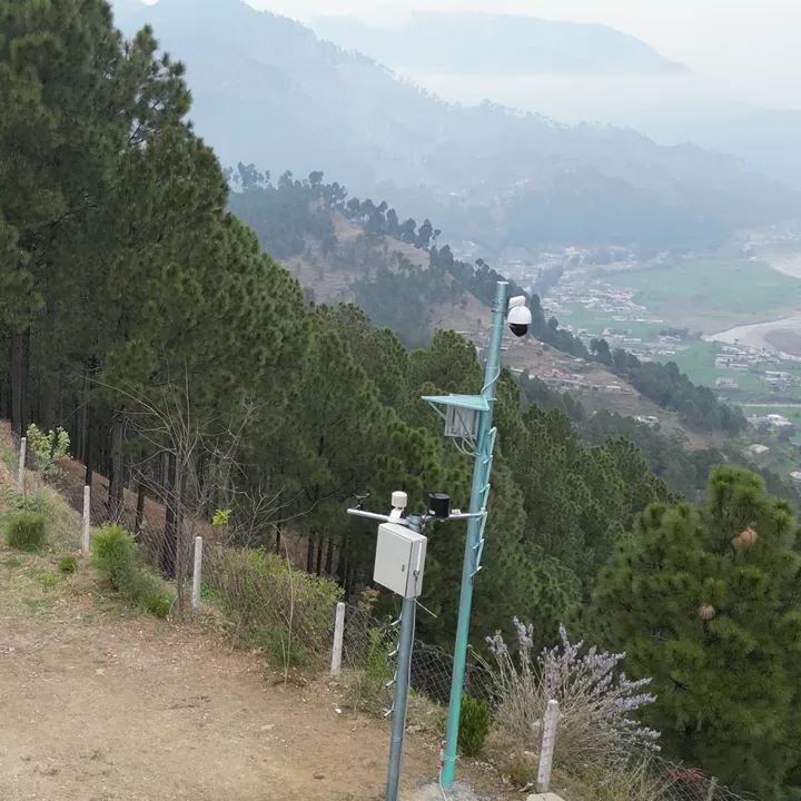
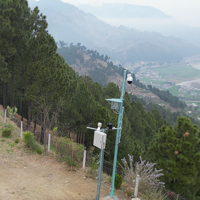
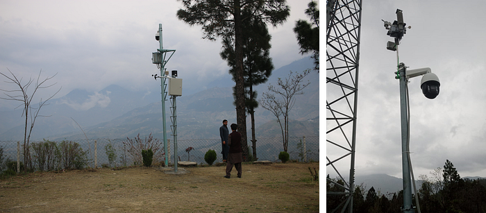
Our first goal was to deploy the camera at the pilot site in order to validate our MVP within real field conditions. After testing the equipment for three tower sites at LUMS facility, the PTZ camera team successfully completed deployments at two tower locations, one in the east and the other in the west, in Mansehra District of KPK as soon the locations were made available.
The field deployment of PTZ camera was most challenging due to the power and viewpoint requirements. Ideally, forest watchtower sites should offer an unobstructed view of the forest and have easy access to power and communication infrastructure. Initially, we had planned to utilize an existing telecom tower for mounting the cameras, as they provided not only access to power but also the durability and height required, whilst reducing the installation cost. Unfortunately, the collaboration with the local telecom operator did not materialize in time for us to secure this option.
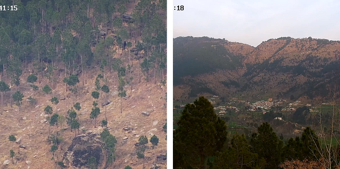
Finding alternative locations that met the necessary requirements proved difficult. The high peak which provided unobstructed view lacked access to power. However, locations that had access to power were surrounded by tall trees, obstructing the view and requiring the installation of towers . In the absence of telecom tower availability, we showed that the system can be deployed by installing custom designed poles. Such customization in our pilot study resulted in a compromise on the height of the pole. In our pilot we used much shorter poles (only 20ft compared to the originally expected 100ft of the telecom tower). This resulted in around 40% obstruction in the camera’s field of view at one of the sites, meaning that the system will be able to fully monitor the northern portion of the site, comprising of most of the forest, but will not be able to cover Southern portion at this location.
Despite all the challenges, we were able to extract live streams from the both camera sites at high-definition video quality with a maximum delay of 15 seconds. We were also able to get a burst of images at regular intervals so that the AI module can identify the presence of smoke or fire in the scene. Finally, the system was enabled for sounding a warning alarm and audio communication with field staff via an installed watch tower.
Although the goal of the pilot was to deploy the system at three sites, two of the four sites were rejected on the basis of these challenges. As a result, we are currently exploring a third site and are hoping to complete the third deployment before the peak summer months to ensure we gain maximum output and learning from this pilot.
Whilst this part of the MVP is complete, we learned that optimal site selection is most important to ensure maximum effectiveness of the system. To achieve this, we plan to incorporate off-grid camera sites, eliminating power and connectivity constraints, and further enhance our ability to select the most suitable locations.
IoT Network Deployments
In our efforts to build a scalable and cost-effective network for forest fire detection, we initially chose to use IoT-based sensors and weather stations within the LoRaWAN-based device ecosystem. Our assumption was that these IoT sensors could provide complementary information for forest fire detection, using products that are easy to source and a network that is easy to scale. However, we soon realized that the available off-the-shelf sensors had a limited range of options for outdoor sensors suitable for fire signatures monitoring so we also procured GSM-based embedded IoT modules from the local market to deploy a custom-built weather station at one of the tower locations.
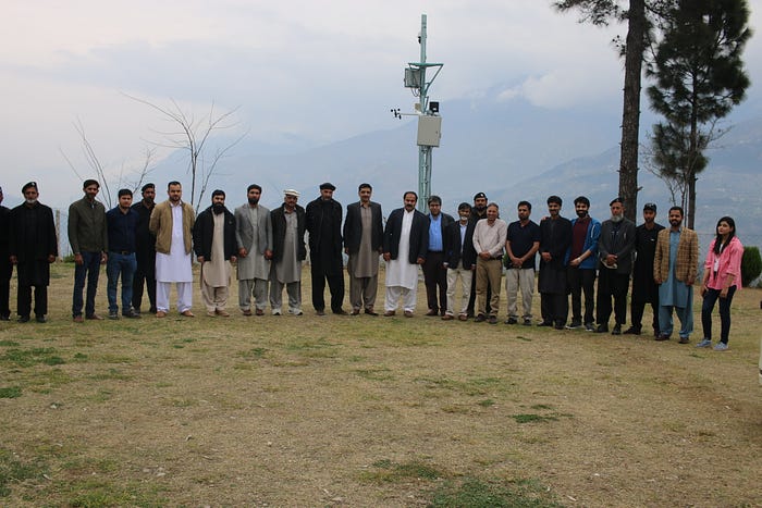
This allowed us to develop need-specific customized solutions using open-source communities within the available resources, enhancing our capability and scalability. We deployed a modular, off the shelf, LoRaWAN-based IoT weather station at the east tower and our custom-built GSM-based weather station at the west tower. The LoRaWAN weather station at the east tower is currently configured to share weather telemetry every 20 minutes, including wind speed, wind direction, precipitation, temperature, humidity, illuminance, total solar radiation (TSR), and atmospheric pressure. The weather station and IoT gateway require power, which can be supplied using a 25W solar panel as was tested at LUMS facility, but since we already had grid power availability on site, we used that instead for the duration of the pilot. Our custom-made weather station at the west tower functions similarly, sharing the same data every 20 minutes, with the exception that it lacks total solar radiation and pressure sensors.
For the IoT network-based forest fire detection, we tested a variety of sensors, including temperature and humidity sensors, TVOC sensors, smoke sensors, particle matter sensors, and CO2 sensors. Temperature and humidity sensors were easily available, cost-effective, and power-efficient, making them a suitable choice for our network. TVOC sensors had some low-cost and power-efficient options, but not many were designed for outdoor scenarios. Smoke sensors were generally power-hungry and not easily available off the shelf, but they could be integrated using generic IoT nodes. Particle matter sensors had average power requirements and promising fire sensing potential, but they required customized IoT node development. CO2 sensors were easy to source and power-efficient, although a bit expensive. The purpose of using various sensors was to ensure comprehensive monitoring of different forest parameters, as no single sensor can provide complete coverage for all scenarios. It is crucial to monitor a diverse set of parameters to detect forest fires accurately and in a timely manner.
While the weather stations were deployed at a central location, along with the PTZ Cameras and the IoT gateways, the deployment of IoT sensors presented its own set of challenges. These sensors needed to be placed inside the forest, making it a challenging task. During this pilot, we utilized the opportunity to test sensor placement and gather valuable data on communication. One of the key factors that can impact forest deployments is the range of the LoRaWAN sensors from the gateway, thus range testing was a critical milestone that we successfully achieved. We even tested our IoT sensor nodes at 10 km line-of-sight distance from the tower location. Through this testing, we gained a better understanding of the forest environment and were able to make informed decisions on sensor placement for future deployments.
With these activities we completed the MVP and learned that off the shelf battery powered LoRaWAN devices can be used for forest monitoring, while customized devices can be developed for more comprehensive forest monitoring (more on this later). Moving forward, we will check the feasibility of solar-powered sensors under forest cover. While LoRaWAN is an excellent communication and ecosystem of products, one size does not fit all, and custom product development is often necessary to address specific challenges of a use case or the geography/infrastructure context. This approach also enabled us to suggest many more innovations for the future that we have mentioned in the ‘Learnings, Possibilities, and the Road Ahead’ section.
Fire Prediction and Spread Models and Field Data Collection
The remote sensing component played a vital role in the mitigation aspect of the pilot project. Our goal was to leverage data from various sources such as satellite imagery, live weather information from the Open Weather API, on-site weather stations, and local data collection, to develop a system that not only predicts forest fire hotspots, but also the speed and direction of spread. This required building an AI model and its visualization tool as well as collecting field data for fine-tuning the AI.
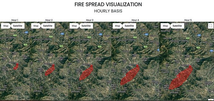
We were able to develop a system that effectively integrated inputs from multiple sources to feed AI models and dashboard visualizations. The comprehensive approach allowed for accurate hotspot estimation, enabling better decision-making and risk mitigation. The primary data attributes included hotspot confidence (low, nominal, high) and fire radiative power (FRP) — which represents the pixel-integrated fire radiative power in MW (megawatts), as well as wind speed and direction.
To visualize the spread of fires, our team employed a three-step workflow. First, we collected local data, then input this data into the Rothermel Fire Spread Model, and finally, fed the output into visualizations for fire spread. This process allowed for a comprehensive understanding of potential fire behaviour and spread patterns in the area. By combining local data collection with satellite and weather data, the remote sensing team was able to create a robust and accurate fire spread model, enhancing the effectiveness of the early warning system.
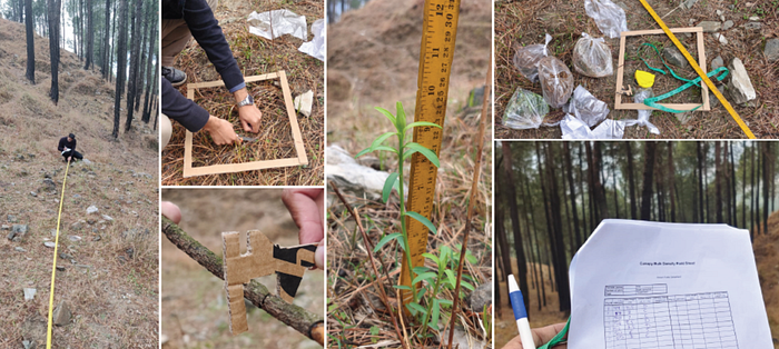
In order to build remote sensing-based fire spread models, it is crucial to collect local field data for fine-tuning the AI models. This is because AI models require accurate and representative data to understand the complex interactions between environmental factors and fire behaviour, which in turn enables the creation of more precise predictions. During the field visits to the two tower sites, data on forest fuel samples, elevation measurements, tree species etc. was collected to inform the Rothermel Fire Spread Model to support the accurate prediction of fire behaviour.
The remote sensing team faced several challenges during this data collection phase, as they ventured into a relatively unexplored area with limited prior research to guide their efforts. Acquiring crucial information that ideally would have been accessible through forestry departments proved to be difficult and developing a data collection methodology required considerable time and resources. Despite these constraints, the team persevered and created a practical manual for data collection. They also encountered onsite challenges such as navigating treacherous terrain, slippery slopes, and coping with increased moisture content due to rainfall. Additionally, the small size of the field survey team, comprising only two members, added complexity to covering as much ground as possible within a tight timeframe.
Unfazed by these obstacles, the team successfully gathered essential local data that, when combined with satellite and weather information, significantly enhanced the fire spread model’s accuracy. Their determination and adaptability not only contributed to the early warning system’s success but also highlighted the immense potential of remote sensing technology and data-driven decision-making in mitigating risks posed by natural disasters like forest fires.
Integrating the parts
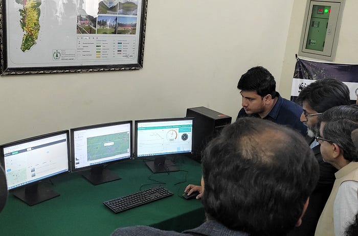
In order to effectively detect forest fires and provide real-time information to end-users, we recognized the need for a unified platform that could seamlessly integrate data from multiple sources and present them to end users, allowing them access to latest telemetry and alerts in a human centric way.
During the deployment, we used the opportunity to build our dashboard and integrate all relevant data sources into a unified platform. This ensured that all hardware components, data streams, and algorithms were functioning properly, allowing for seamless communication between systems. The dashboard combined data from sensors, cameras, and remote sensing models, providing end-users with real-time information and insights for decision-making during forest fire incidents.
During this sprint, we also tested the option to integrate community based early warning into our overall early warning system using mobile SMS. WhatsApp for Business was initially explored for community-based early warning alerts, but challenges were faced during the setup of the automatic reply message and menu. Such automated replies are subject to review by the WhatsApp team and in our case our menus containing keywords such as “fire” and “smoke” got rejected. This could be a result of our social innovation message related to forest fires being incorrectly classified as a restricted category under the WhatsApp Business Commerce Policy which prevents the service from being used for activities related to firearms and explosives. Going forward, we will explore alternative communication channels, such as other messaging platforms or mobile apps, to offer a more reliable alert system.
During the integration process, we learned that a scalable and stable system can be built by integrating various independent platforms that address different parts of the system, such as cameras, IoT sensors, and remote sensing models. This allows for scalability and stability, as data from different sources will still be available even if one source experiences downtime. Additionally, different modules can be scaled independently without dependencies on other components. For example, there can be more towers with just PTZ cameras or weather stations in certain locations. This approach will enable us to build a flexible and adaptable system that can be customized to meet the unique needs of different regions and ecosystems.
We will continue to collaborate with stakeholders to identify the most effective communication methods for reaching target communities and supporting their needs during forest fire events. This will ensure our early warning system remains responsive, accessible, and able to provide timely alerts when needed most.
What is Next
Fine-tuning the AI
The immediate next step is collecting the data from the field deployments to improve our AI based analysis of smoke and fire detection, in order to increase the robustness of the automated generation of alerts. For example, the AI system for detecting smoke and fire will be fine-tuned with site-specific images to reduce false positives arising from confusion between low-altitude clouds, smoke, fire, and changes in sky colour during sunset.
Testing and validating the system
To validate and improve the effectiveness of the system, we plan to test it during the upcoming summer season, when several fire incidents are expected to occur. Our primary objective is to calculate the false positive and true positive rates of the system and learn from the results. We will closely collaborate with WWF and the Forest Department to compare the records generated by the AI system with the field records and make necessary improvements.
Testing communication systems for off-grid deployment
One of the goals for the future is to enable the deployment of our solution in areas with limited or no connectivity by implementing alternate communication options for both high and low bandwidth requirements. By addressing this challenge, we aim to expand the system’s applicability and coverage to a broader range of locations. In subsequent sprints, we will test and evaluate the effectiveness of the selected communication technologies for various use cases, ensuring that our solution can operate effectively even in the most remote and challenging environments. This approach will help us to create a more resilient and adaptable system that can function under various connectivity conditions.
Stakeholder engagement
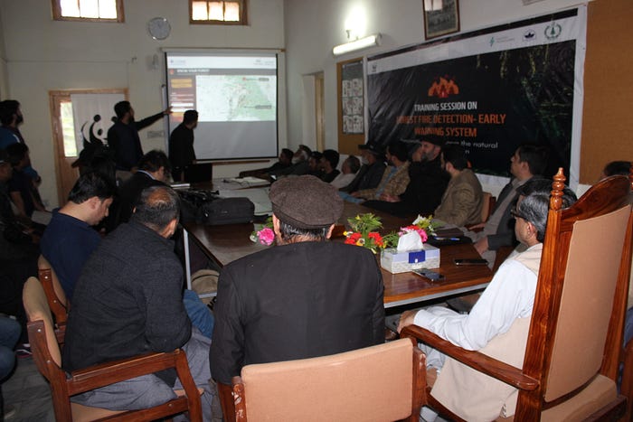
Although the system has been handed over to the forest department, we aim to increase our engagement with the relevant forest officers. This will include organising training sessions and engaging with forest guards to assist them in improving their response to fire incidents.
Closing the loop
At the end of the forest fire season, we will develop a report to detail the fire incidents reported in the region, incidents reported within a 15km radius of the watch tower, incidents reported by the system, readings of different sensors during the period of fire/smoke incident and other relevant details. The report will also include feedback from the forest department over how useful they found the solution and any desired changes they would like to see within the dashboard to make the system more effective.
The aim of this report will be to evaluate the effectiveness of the solution in terms of identifying and reporting forest fires and to collect feedback from stakeholders in order to iterate on the dashboard design and build capabilities for any technological shortcomings observed by them for the future deployments.
Insights to Innovations: Learnings, Possibilities, and the Road Ahead
Working in sprints is all about building minimum viable products (MVPs) and adapting as we learn. Through our stakeholder engagement activities, we have gained valuable insights and suggestions that will guide our system’s future development and deployment. These insights have allowed us to envision a broader scope for the system beyond its current application, which will enable us to build interventions that promote holistic forest management and protection. In this section, we will discuss the key takeaways from our engagement activities and how we plan to incorporate them into our future plans.
IoT Sensors for Advanced Forest Ecosystem Research and Management
A potential future application of IoT sensors is their deployment for forest asset management and research purposes. This includes incorporating canopy temperature sensors and sap flow sensors, which can provide valuable insights into the health and dynamics of the forest ecosystem. Dr. Awais, who is leading the remote sensing component of the project, has extensive experience in forest asset monitoring and management, having previously collaborated with WWF and the Forest Department.
The integration of IoT sensor data with the existing forest knowledge management platform can significantly enhance its capabilities, enabling researchers and forest managers to gain a more comprehensive understanding of the forest ecosystem. By combining real-time data from IoT sensors with inventory data and remote sensing information, the platform can provide valuable insights into forest inventory, carbon stock, carbon sequestration potential, and tree health.
This application of IoT sensors for research purposes can help identify potential risks and opportunities in forest health and support the development of targeted interventions and adaptive management strategies, ensuring the long-term sustainability and resilience of our forests.
Detecting Human-Caused Incidents and Identifying Perpetrators in Forest Fires
In addition to its primary function of detecting natural forest fires, the fire detection system can also be extended to identify and prevent human-caused incidents. According to the research conducted by our pilot partner, WWF-Pakistan, insights from local stakeholders show that, other than natural causes, a significantly large number of forest fires in our pilot region were due to human negligence. This prompts two critical questions: i) how to verify such claims and ii) how to reduce such incidents? Given that natural fires occur only under certain weather conditions such as a prolonged dry season and increased temperatures, a possible future task is to correlate each fire incident with the sensor data to statically identify the causes of fire.
To reduce such incidents, laws have been put in place. However, identifying and catching the culprits behind the fire incidents is a crucial first step. The deployed camera solution, which allows for live streaming and up to 32x optical zoom, presents a viable option for identifying the individuals responsible for fire incidents. Additionally, the fire department plans to leverage the system to monitor illegal deforestation activity.
Enhancing Forest Protection by Human Presence Monitoring
Forest serves as a source of many resources the local community depends on, such as wild honey, fuel wood, herbs etc. Thus, the local community regularly visits the forest to fulfil these needs. However sometimes illegal activities are also performed such a deforestation, hunting, initiating fire to hide deforestation etc. In this regard the forest department wanted to have a simple solution that can inform them about the ongoing human activity in the forest. A potential extended use case of the fire detection system could be to monitor human activity in the forest, which is essential for protecting the forest such illegal activities.
Since our system is already solving the communication challenges, additional solutions can be introduced to protect the forest. The Pax Counter is one such IoT-based solution which was introduced to the forest officers during the training workshop, catching their attention for improving human activity monitoring in the forest. The Pax Counter monitors human activity patterns by tracking their digital signatures, such as mobile Bluetooth and Wi-Fi signals. The potential solution could be that whenever the Pax Counter generates a human activity warning, the PTZ camera can be programmed to take zoomed-in shots of that region for monitoring purposes.
However, privacy concerns are a crucial factor to consider while implementing a solution like the Pax Counter for human activity monitoring in the forest. The Pax Counter does not need to persistently store any personal identifying data or perform any kind of fingerprinting on the scanned devices in order to count human traffic or activity levels. The technology can be developed and used solely for the purpose of improving forest protection without intruding on individuals’ privacy.
Audio-Based IoT Solutions for Detecting Illegal Deforestation
Cameras, while useful, inherently possess a limited field of view. In contrast, audio can be captured from all directions, providing a more comprehensive monitoring solution. Incorporating audio-based monitoring systems for identifying ongoing activities in the forest is an area that the forest department is interested to explore.
One approach involves deploying IoT decibel monitors throughout the forest. These devices can measure ambient noise levels and detect any sudden spikes or unusual patterns, potentially indicating suspicious activities. For instance, the sound of chainsaws or heavy machinery could signal illegal logging or other forms of deforestation.
Another promising avenue is the use of low-cost, AI-based sound sensors that can analyse and classify various sounds in the forest. These intelligent devices can be trained to recognize specific noises associated with human activities, wildlife, or natural events. By distinguishing between common forest sounds and potential threats, these sensors can help the forest department quickly respond to incidents before they escalate.
Combining these audio monitoring solutions with existing camera systems can significantly enhance the forest department’s ability to detect and prevent illegal activities, leading to better forest management and conservation. In addition, the collected audio data can also be used for research purposes, enabling scientists to study the forest’s acoustic ecology and better understand the dynamics of its ecosystem.
Importance of Industry-Academia collaboration and the role of NGOs like WWF
The importance of industry-academia collaboration and partnerships with NGOs like WWF is evident in this project. The constructive collaboration between LUMS, WWF-Pakistan, the KPK Forest Department, and other stakeholders has enabled the development and deployment of an innovative forest fire prevention system, tailored to local needs and context.
NGOs like WWF play a crucial role in facilitating such collaborations, bridging the gap between government, academia, and industry, and fostering impact-driven research. Their involvement ensures that solutions remain grounded in both scientific rigor and practical implementation, addressing pressing environmental challenges.
Engaging local communities in the project’s implementation is vital to ensure sustainability and a deeper understanding of their needs. The success of this project demonstrates the power of strong partnerships in addressing global environmental challenges and promoting sustainable development for future generations.
Conclusion
The LUMS team, in collaboration with WWF-Pakistan, has made significant strides in developing technology-driven solutions for early detection and response to forest fires. By reflecting on the lessons learned and insights from end users, the project continues to evolve and adapt to the real-world needs of forest protection. This project exemplifies the power of collaboration and innovative technology in tackling pressing environmental challenges. Through the development and deployment of AI, IoT and remote sensing-based solutions, the project addresses crucial aspects of forest fire prevention, including early detection, communication, and human activity monitoring. The cost effectiveness aspect of the multi-modal and modular forest fire system also enables scalability to other sites. As the initiative evolves, it will continue to integrate feedback from end users and explore new avenues for improving forest management, such as the incorporation of additional sensors for research purposes and asset monitoring.
The success of this project underscores the importance of industry-academia collaboration and the vital role that NGOs like WWF play in fostering impact-driven research. By bridging the gap between government, academia, and industry, these partnerships ensure that solutions are grounded in both scientific rigor and practical implementation. Engaging local communities in the process further contributes to the project’s sustainability and adaptability to real-world needs.
Moving forward, we hope to continue leverage the industry-academia linkages to drive innovation and address the grand challenges of climate change and forest conservation. By investing in early warning systems and monitoring technologies, the project lays the groundwork for a scalable and efficient system that safeguards our forests for the benefit of future generations.