

Smarter Farming, Lower Cost: How WIT is Reimagining Precision Agriculture for Pakistan
By combining affordable consumer drones with powerful in-house AI, the Centre for Water Informatics and Technology (WIT) is building tools that put data-driven farming within reach of everyone.
Drones are taking precision agriculture to the next level. By enabling highly targeted spraying, reducing chemical overuse, and providing real-time information about crops, they help farmers boost productivity while minimizing environmental impact.
Pakistan’s agricultural sector has struggled to benefit from the global rise of precision agriculture. Most farmers still rely on traditional practices, such as flood irrigation and heavy use of fertilizers and pesticides—methods guided by routine rather than data. These approaches miss out on the wealth of information now available from satellite imagery, drone-based monitoring, and IoT sensors, leading to inefficient water use and limited visibility into crop health. Smallholder farmers also face significant barriers, including limited technical training, weak digital infrastructure, and difficulty interpreting complex digital data, all of which make modern tools difficult to adopt. This creates a clear need for technologies that are affordable, easy to use, and tailored to Pakistan’s local farming conditions.
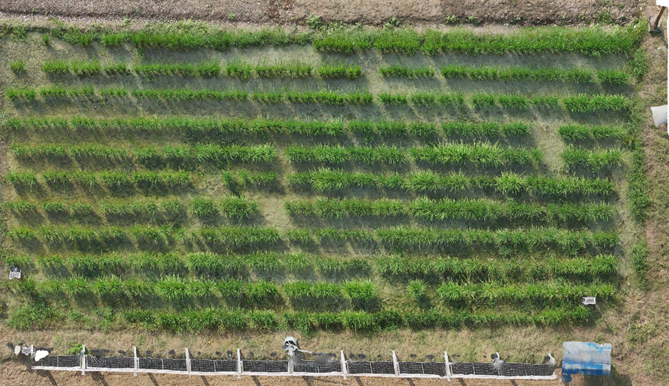
Rice crop imagery collected at LUMS Digital Sustainable Agriculture Facility during the current Kharif season 2025.
Addressing these challenges is a major research thrust at the NCRA-Agricultural Robotics Lab (NARL), established at the Centre for Water Informatics and Technology (WIT) at LUMS. Dedicated to achieving high water efficiency, reliable crop monitoring, and a lower environmental footprint, the lab is led by Principal Investigator (PI) Dr. Abubakr Muhammad and Co-PIs Dr. Mian Muhammad Awais, Dr. Murtaza Taj, and Dr. Hassan Jaleel. Our work focuses on developing practical, locally relevant technologies that enable information-driven decision-making in agriculture. By combining expertise in drones, automation, and environmental sensing, the lab creates precision-agriculture solutions that are accessible to farmers with limited technical know-how.
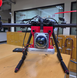
Led by Dr. Hassan Jaleel, the team is advancing drone-based imaging and AI-powered analytics for crop-health assessment, yield prediction, and plant phenotyping. A key focus of this initiative is ensuring these tools are truly accessible. Instead of relying on large industrial drones, which are expensive, require certified operators, and often face strict regulatory restrictions, the team uses compact consumer-grade drones such as the DJI Mini 4 Pro. These drones are affordable, widely available in local markets, and simple enough for non-professionals to operate. Despite their size, they capture high-resolution aerial images that carry valuable information about crop conditions.
To turn these images into useful insights, WIT has developed its own computer vision and photogrammetry pipelines. These advanced processing tools convert raw aerial photographs into detailed three-dimensional maps of crop fields. These 3D reconstructions help identify problem areas, detect early signs of crop stress, and monitor growth patterns with far greater accuracy than traditional field visits. Building on this foundation, WIT is developing AI models that can automatically count plants, detect panicles in rice or heads in wheat crops, and compute multiple vegetation indices to estimate yields and assess crop health. Together, these innovations demonstrate how low-cost drone systems can now provide high-value analytics that were once possible only with expensive, specialized equipment.

Rice crop imagery collected at LUMS field during the current Kharif season 2025. (Left) Results of plant counting using a pretrained model. (Right) Rice panicle counting for yield estimation.
Alongside consumer drones, WIT is also designing custom-built drone platforms equipped with LiDAR and integrated cameras. These advanced systems combine multiple sensors to create highly precise, high-resolution 3D maps—an essential capability in fields with dense crops or uneven terrain. By creating both off-the-shelf and custom solutions, WIT is ensuring that precision agriculture tools remain adaptable to the diverse needs of Pakistani farmers.

High-resolution 3D point cloud of the LUMS Digital Sustainable Agriculture Facility (LUMS Field) generated using LiDAR technology.
This initiative was developed by a dedicated team of Research Assistants at WIT and students from the Electrical Engineering and Computer Science departments:
Muhammad Ahson Hassan
Hussain Habib
Sheza Abbas Naqvi
Syed Shayaan Haider
Maheen Raza
The team contributed to all facets of the project, from drone development and imaging workflows to the AI analytics that power this work.
Through these efforts, WIT is not just publishing research; it is building practical tools that can pave the way for a more sustainable, productive, and technologically empowered future for Pakistan's agriculture. By proving that high-value analytics are possible with low-cost equipment, this work provides a scalable model for a nationwide agricultural transformation. These on-ground innovations also complement the broader strategic efforts of WIT’s emerging Food+Agriculture systems modeling group, which collaborates with the FABLE Consortium Pakistan to address critical Water-Food-Energy nexus challenges.
Acknowledgment: This research was funded by the Higher Education Commission (HEC) of Pakistan under the National Research Program for Universities (NRPU).
Learn more about this research or explore collaboration opportunities:
Visit the Centre for Water Informatics and Technology (WIT) website.
Contact Dr. Hassan Jaleel for details on the project.
Explore other WIT Research Projects.